Mohammad Al-Idrisi and the Impact of Roger’s Map
Introduction to Mohammad Al-Idrisi
Mohammad Al-Idrisi, born in 1100 in Ceuta (now part of Spain), was a renowned Arab geographer, cartographer, and Egyptologist. He created the “Tabula Rogeriana” or “Roger’s Map” in 1154, which significantly impacted both the Islamic and Western worlds. Explorers and scholars used it as a crucial tool for centuries.
Al-Idrisi’s Travels and Compilation of Knowledge
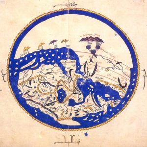
Al-Idrisi spent much of his life traveling and gathering knowledge from various cultures and regions, meticulously documenting his findings. He traveled across the Mediterranean, including North Africa, Europe, and the Middle East. At the request of King Roger II of Sicily, Al-Idrisi compiled his extensive knowledge into a comprehensive world map, which also included a geographical text. The “Tabula Rogeriana,” illustrated in the second image, culminated decades of research and became the most detailed world map of its time.

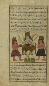
This illustration shows Al-Idrisi or a related scene. It depicts a central crowned figure seated at a desk with tools, surrounded by two other crowned figures, reflecting the rich historical context of his work.
The Unique Features of the Tabula Rogeriana
He depicted Europe, Africa, and Asia on the map, which he drew on a silver disc. The map included detailed descriptions of the climate, culture, and topography of various regions. It uniquely combined knowledge from both Islamic and Western sources, achieving remarkable accuracy and scope.

This map, known as the “Tabula Rogeriana,” represents the known world of the medieval period. Al-Idrisi oriented it with the South at the top, a common practice in Islamic cartography, showcasing his comprehensive geographical knowledge.
Impact of “Roger’s Map” on the Western World
“Roger’s Map” revolutionized the Western world for several reasons:
- Geographical Accuracy: The map offered unprecedented accuracy in depicting various regions. It corrected many misconceptions Europeans held and provided a reliable reference for future cartographers and explorers.
- Influence on Exploration: Al-Idrisi’s map served as a key resource during the Age of Exploration. European explorers, including Christopher Columbus, benefited from its detailed information about distant lands.
- Cultural Exchange: The map facilitated a significant exchange of knowledge between the Islamic and Western worlds. Al-Idrisi’s work stands as one of the earliest examples of collaboration that transcended cultural and religious boundaries, fostering greater understanding between East and West.
- Long-lasting Legacy: For over three centuries, Europeans relied on “Roger’s Map” as a primary reference for geographical knowledge. They translated it into several languages and used it as the foundation for future maps, shaping how they perceived and navigated the world.
The Mythical Islands of Waq Waq and Their Connection to Atlantis
One of the most intriguing aspects of Al-Idrisi’s work is his depiction of the mythical islands of Waq Waq. He placed these islands far east of known lands. Al-Idrisi’s descriptions of Waq Waq closely resemble Plato’s accounts of Atlantis, an advanced civilization that people believed existed beyond the Pillars of Hercules (modern-day Strait of Gibraltar).
Both Waq Waq and Atlantis depicted utopian societies with advanced knowledge and technology. Yet, both also mysteriously disappeared. The similarities in these tales suggest that stories of Atlantis may have influenced the Arab world’s concept of distant, mysterious lands like Waq Waq. This blending of mythologies illustrates the interconnectedness of ancient civilizations and shows how legends evolved and spread across cultures.
Legacy and Influence of Mohammad Al-Idrisi’s Work
Mohammad Al-Idrisi’s “Roger’s Map” was more than just a monumental achievement in medieval cartography; it also bridged Eastern and Western knowledge. His work laid the foundation for future exploration and geographical understanding, profoundly influencing modern culture and thought. Al-Idrisi’s detailed representation of the world corrected many misconceptions of his time and promoted the exchange of ideas between the Islamic and Western worlds. His depiction of the mythical islands of Waq Waq, with their intriguing parallels to Plato’s Atlantis, underscores the deep interconnectedness of ancient myths and their enduring impact on both Eastern and Western cultures. This blending of mythology and geography in Al-Idrisi’s work continues to resonate today. It reminds us of our shared human knowledge and the importance of cross-cultural understanding in shaping our world.


